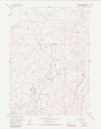
1957 Map of Double Butte
USGS Topo · Published 1985About this map
Reservoirs and seasonal watercourses define this high Wyoming landscape within the Missouri River Basin during the mid-20th century. Named for the prominent Double Butte, the area features a series of man-made catchments including Logan Junction Reservoir, North Logan Reservoir, and the colorfully named Sucker Reservoir. These water sources are linked by the winding paths of Logan Gulch and Conant Creek, illustrating the vital importance of water management for livestock or local industry in this semi-arid environment. Along Signor Ridge, the map records an Oil Well (inactive), marking a quiet chapter in the region’s energy exploration. The terrain is characterized by broad draws like Signor Draw and family-named landmarks such as Homestead Flat Reservoir, which suggest a history of ranching and early settlement attempts.
Find a feature on this map
13 named features on this map. Tap any name to fly to it.
Don’t see what you’re looking for? This feature index may not catch every label — zoom into the map to look around manually.
Map Details
Editions of this 1957 Double Butte Map
2 editions found
Other maps of this area

1951 · Fuller Reservoir
USGS Topo · 1:24,000

1952 · Squaw Butte
USGS Topo · 1:24,000

1952 · Rongis Reservoir SE
USGS Topo · 1:24,000

1952 · Double Butte
USGS Topo · 1:24,000

1952 · Haybarn Hill
USGS Topo · 1:24,000

1952 · Rongis Reservoir
USGS Topo · 1:24,000

1952 · Butte Well
USGS Topo · 1:24,000

1953 · Blue Gulch
USGS Topo · 1:24,000

1953 · Campbell Ridge
USGS Topo · 1:24,000

1955 · Thermopolis
USGS Topo · 1:250,000