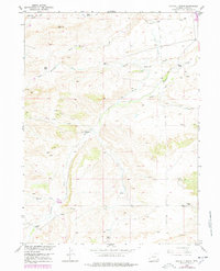
1953 Map of Double L Ranch
USGS Topo · Published 1978About this map
The ranching landscape of Platte County, Wyoming, is captured here as it appeared in the mid-20th century. Named family holdings like Double L Ranch, Grant Ranch, and the Lewis Ranch are distributed across a terrain carved by the drainage systems of Richeau Creek and Hunton Creek. These watercourses, along with their various branches such as North Richeau Creek and South Hunton Creek, were critical to the operation of high-plains livestock operations. The map illustrates the infrastructure of rural life in this era, showing several Windmills, a persistent Pipe Line, and a system of irrigation ditches, including a prominent Ditch near Walker Draw. Surveyed as part of the Department of the Interior's Missouri River Basin development program, the map documents a transition from early homesteading to established modern ranching, with high points like VABM 5890 Hunton and VABM 5700 Knoll serving as permanent geographic markers.
Find a feature on this map
24 named features on this map. Tap any name to fly to it.
Don’t see what you’re looking for? This feature index may not catch every label — zoom into the map to look around manually.
Map Details
Editions of this 1953 Double L Ranch Map
3 editions found
Other maps of this area

1953 · Double L Ranch
USGS Topo · 1:24,000

1953 · Chugwater
USGS Topo · 1:24,000

1953 · Natwick
USGS Topo · 1:24,000

1953 · Ferguson Corner
USGS Topo · 1:24,000

1953 · Bordeaux
USGS Topo · 1:24,000

1953 · Richeau Hills
USGS Topo · 1:24,000

1954 · Cheyenne
USGS Topo · 1:250,000

1958 · Cheyenne
USGS Topo · 1:250,000

1962 · Mc Donald Ranch
USGS Topo · 1:24,000

1962 · Bristol Ridge NE
USGS Topo · 1:24,000