
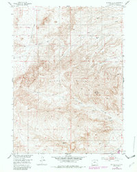
1953 Map of Richeau Hills
USGS Topo · Published 1954About this map
Richeau Hills dominate the topography of this Platte County landscape, surveyed in the early 1950s as part of a Missouri River Basin development program. The map illustrates a high-altitude grazing environment defined by isolated ranching outposts and a complex network of intermittent water sources. Named landmarks like Hill Ranch and Home Ranch Spring suggest a history of early land claims centered on the few reliable water points in an otherwise arid upland.
Find a feature on this map
12 named features on this map. Tap any name to fly to it.
Don’t see what you’re looking for? This feature index may not catch every label — zoom into the map to look around manually.
Map Details
Editions of this 1953 Richeau Hills Map
2 editions found
Other maps of this area

1953 · Natwick SW
USGS Topo · 1:24,000

1953 · Double L Ranch
USGS Topo · 1:24,000

1953 · Natwick
USGS Topo · 1:24,000

1953 · Squaw Rock
USGS Topo · 1:24,000

1953 · Ferguson Corner
USGS Topo · 1:24,000

1954 · Cheyenne
USGS Topo · 1:250,000

1958 · Cheyenne
USGS Topo · 1:250,000

1962 · Delano Ranch
USGS Topo · 1:24,000

1962 · Mc Donald Ranch
USGS Topo · 1:24,000
1962 · Whitcomb Hill
USGS Topo · 1:24,000