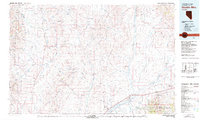
1981 Map of Double Mtn
USGS Topo · Published 1982About this map
The North Fork Humboldt River and Marys River converge in this high desert landscape, forming a critical drainage basin north of the Adobe Range. In the early 1980s, this area of Elko County remained defined by its ranching corridors and the legacy of early 20th-century land developments, most notably at Metropolis. The transportation network is anchored by the dual routes of the Southern Pacific and Western Pacific railroads, which parallel the Humboldt River and Interstate 80 through the southern portion of the map. Smaller settlements like Deeth, Welcome, and Tulasco serve as points of interest along these rail lines. To the east, the Starr Valley opens up below the peaks of the Humboldt National Forest, while more remote landmarks such as Peko Pk and the Lost Wallet Rim punctuate the high-elevation terrain between the river forks.
Find a feature on this map
107 named features on this map. Tap any name to fly to it.
Don’t see what you’re looking for? This feature index may not catch every label — zoom into the map to look around manually.
Map Details
Editions of this 1981 Double Mtn Map
2 editions found
Other maps of this area

1935 · Halleck
USGS Topo · 1:125,000

1935 · Charleston
USGS Topo · 1:48,000

1942 · Mt. Velma
USGS Topo · 1:62,500

1955 · McDermitt
USGS Topo · 1:250,000

1955 · Wells
USGS Topo · 1:250,000

1955 · Winnemucca
USGS Topo · 1:250,000

1955 · Elko
USGS Topo · 1:250,000

1956 · Tuscarora
USGS Topo · 1:62,500

1956 · Bull Run
USGS Topo · 1:62,500

1956 · Wild Horse
USGS Topo · 1:62,500