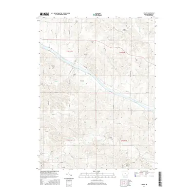
2015 Map of Douds
USGS Topo · Published 2015About this map
The Des Moines River bisects this Van Buren County landscape, where the twin settlements of Douds and Leando face one another across the water. This 2015 topographic study captures a region deeply tied to its rural heritage, evidenced by the high concentration of small, family-named burial grounds dotting the township lines. Genealogists and local historians can trace the geography of established community landmarks like the Boyer Family Cem and Zion Lutheran Cem in the north, or Valentine Cem and Groves Cem to the south. The terrain is defined by the winding paths of Chequest Cr and Holcomb Cr, while the inclusion of the Oldfield Aero Airport illustrates the modern aviation footprint within this traditional agricultural setting. The layout of county roads, such as Co Hwy V64, reveals how the transportation network still revolves around these historic river crossings.
Find a feature on this map
58 named features on this map. Tap any name to fly to it.
Don’t see what you’re looking for? This feature index may not catch every label — zoom into the map to look around manually.
Map Details
Editions of this 2015 Douds Map
This is the sole edition of this map. No revisions or reprints were ever made.
Other maps of this area

1954 · Centerville
USGS Topo · 1:250,000

1957 · Centerville
USGS Topo · 1:250,000

1958 · Centerville
USGS Topo · 1:250,000

1958 · Burlington
USGS Topo · 1:250,000

1961 · Burlington
USGS Topo · 1:250,000

1963 · Burlington
USGS Topo · 1:250,000
1965 · Eldon
USGS Topo · 1:24,000

1965 · Selma
USGS Topo · 1:24,000
1965 · Libertyville
USGS Topo · 1:24,000

1965 · Douds
USGS Topo · 1:24,000