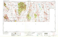
1959 Map of Douglas
USGS Topo · Published 1971About this map
Mining operations and border trade anchor this high-desert landscape in the late 1950s. The sprawling Sulphur Springs Valley separates the Mule Mountains from the towering Chiricahua Mountains, where the Chiricahua National Monument preserves a labyrinth of rock formations. In the west, the concentrated urban cluster of Bisbee, Lowell, Warren, and Don Luis reflects the region's intense mineral heritage, while to the south, Douglas and Pirtleville sit directly against the United States Mexico border.
Find a feature on this map
59 named features on this map. Tap any name to fly to it.
Don’t see what you’re looking for? This feature index may not catch every label — zoom into the map to look around manually.
Map Details
Editions of this 1959 Douglas Map
4 editions found

Other maps of this area

1899 · Deming
USGS Topo · 1:125,000

1902 · Bisbee
USGS Topo · 1:62,500

1910 · Bisbee
USGS Topo · 1:62,500

1914 · Hereford
USGS Topo · 1:125,000

1914 · Douglas
USGS Topo · 1:62,500

1915 · Benson
USGS Topo · 1:125,000

1915 · Deming
USGS Topo · 1:125,000

1916 · Pearce
USGS Topo · 1:125,000

1916 · Douglas
USGS Topo · 1:125,000

1917 · Hermanas
USGS Topo · 1:62,500