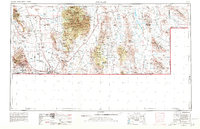
1959 Map of Douglas
USGS Topo · Published 1980About this map
The high desert landscape of the Arizona-New Mexico borderlands is defined here by the dramatic transition from the Mule Mountains to the broad expanse of the Sulphur Springs Valley. During this era of mid-century growth, the mining legacy of Bisbee and its neighboring communities like Warren and Don Luis remains prominent, anchored by the infrastructure of the Southern Pacific railroad. The international boundary is a constant presence, stretching from the port of entry at Naco through the bustling desert hub of Douglas.
Find a feature on this map
65 named features on this map. Tap any name to fly to it.
Don’t see what you’re looking for? This feature index may not catch every label — zoom into the map to look around manually.
Map Details
Editions of this 1959 Douglas Map
4 editions found

Other maps of this area

1899 · Deming
USGS Topo · 1:125,000

1902 · Bisbee
USGS Topo · 1:62,500

1910 · Bisbee
USGS Topo · 1:62,500

1914 · Hereford
USGS Topo · 1:125,000

1914 · Douglas
USGS Topo · 1:62,500

1915 · Benson
USGS Topo · 1:125,000

1915 · Deming
USGS Topo · 1:125,000

1916 · Pearce
USGS Topo · 1:125,000

1916 · Douglas
USGS Topo · 1:125,000

1917 · Hermanas
USGS Topo · 1:62,500