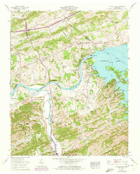
1961 Map of Douglas Dam
USGS Topo · Published 1973About this map
Douglas Dam and the sprawling waters of Douglas Lake dominate this landscape, illustrating the mid-century transformation of the French Broad River valley. The map reveals a complex system of infrastructure, including Saddle Dam 1 through Saddle Dam 10, which contain the reservoir’s reach across the eastern terrain. Inland from the water, the community of Kodak is anchored by the Kodak School and Henry Crossroads, showing the persistence of local hubs even as the valley's geography shifted.
Find a feature on this map
77 named features on this map. Tap any name to fly to it.
Don’t see what you’re looking for? This feature index may not catch every label — zoom into the map to look around manually.
Map Details
Editions of this 1961 Douglas Dam Map
4 editions found
Other maps of this area

1883 · Morristown
USGS Topo · 1:125,000

1886 · Knoxville
USGS Topo · 1:125,000

1892 · Knoxville
USGS Topo · 1:125,000

1893 · Mt Guyot
USGS Topo · 1:125,000

1893 · Morristown
USGS Topo · 1:125,000

1894 · Knoxville
USGS Topo · 1:125,000

1895 · Morristown
USGS Topo · 1:125,000

1895 · Knoxville
USGS Topo · 1:125,000

1897 · Maynardville
USGS Topo · 1:125,000

1900 · Maynardville
USGS Topo · 1:125,000