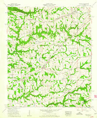
1958 Map of Douglas
USGS Topo · Published 1960About this map
Douglas serves as the primary hub of this agricultural landscape in the late 1950s, situated at a road junction where numerous rural routes converge. The map reveals a high density of community centers, including the Liberty Hill Sch & Cem and Highview Sch, reflecting the localized network of Marshall County's mid-century rural life. The terrain is defined by the prominent Sand Mountain plateau, where a complex system of watercourses like Slab Creek and Mud Creek have carved deep incisions into the topography. Significant local landmarks such as Mt Hebron and Zion Hill anchor the dispersed settlements. This survey by the Tennessee Valley Authority documents the area's intricate drainage patterns and the boundary lines between Marshall, Blount, and Etowah counties, providing a clear record of the region's physical and social organization during a period of steady rural development.
Find a feature on this map
78 named features on this map. Tap any name to fly to it.
Don’t see what you’re looking for? This feature index may not catch every label — zoom into the map to look around manually.
Map Details
Editions of this 1958 Douglas Map
3 editions found
Other maps of this area

1885 · Gadsden
USGS Topo · 1:125,000

1888 · Gadsden
USGS Topo · 1:125,000

1892 · Gadsden
USGS Topo · 1:125,000

1895 · Gadsden
USGS Topo · 1:125,000

1903 · Gadsden
USGS Topo · 1:125,000

1936 · Guntersville
USGS Topo · 1:24,000

1936 · Mountainboro
USGS Topo · 1:24,000

1936 · Arab
USGS Topo · 1:24,000
1936 · Brooksville
USGS Topo · 1:24,000

1936 · High Point
USGS Topo · 1:24,000