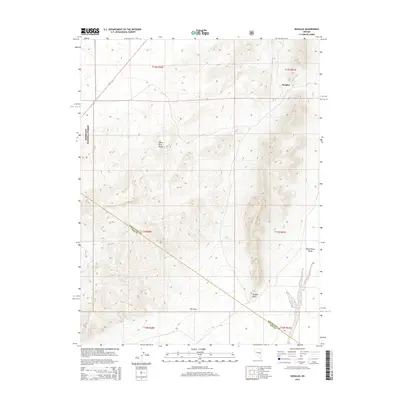
2014 Map of Douglas
USGS Topo · Published 2014About this map
Humboldt National Forest and the White River Range define the high-desert character of this 2014 survey. Located along the border of White Pine and Nye counties, the landscape transitions from the jagged peaks of the range down into the open expanse of the White River Valley. The small settlement of Douglas sits in the northeastern quadrant of the map, situated near the foothills. Throughout this arid terrain, rare water sources like Granite Spring and The Cove suggest the historical importance of specific locations for ranching and travel in this part of Nevada. The topography is dominated by dramatic elevation changes, notably at Douglas Point, illustrating the difficult physical geography that has long dictated movement through these mountain passes and valley floors.
Find a feature on this map
14 named features on this map. Tap any name to fly to it.
Don’t see what you’re looking for? This feature index may not catch every label — zoom into the map to look around manually.
Map Details
Editions of this 2014 Douglas Map
This is the sole edition of this map. No revisions or reprints were ever made.
Other maps of this area

1956 · Lund
USGS Topo · 1:250,000

1957 · Currant Mtn
USGS Topo · 1:62,500

1960 · Lund
USGS Topo · 1:250,000

1964 · Currant
USGS Topo · 1:62,500

1964 · Currant Mtn
USGS Topo · 1:62,500

1969 · Moorman Spring NW
USGS Topo · 1:24,000

1969 · Moorman Spring NE
USGS Topo · 1:24,000
1978 · Lund
USGS Topo · 1:24,000
1978 · Douglas
USGS Topo · 1:24,000
1978 · Badger Hole Spring
USGS Topo · 1:24,000