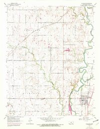
1955 Map of Douglass
USGS Topo · Published 1982About this map
Douglass and the surrounding Butler County countryside appear here as they were mid-century, defined by the confluence of the Walnut River and the Little Walnut River. The township system is clearly visible, with Pleasant, Richland, and Douglass boundaries intersecting across a landscape of agriculture and early oil exploration. Numerous small cemeteries, such as Dunlap Cem, Rose Hill Cem, Friends Cem, and Richland Cem, provide vital clues for genealogists tracking early families of the region.
Find a feature on this map
27 named features on this map. Tap any name to fly to it.
Don’t see what you’re looking for? This feature index may not catch every label — zoom into the map to look around manually.
Map Details
Editions of this 1955 Douglass Map
4 editions found

Other maps of this area

1888 · Eldorado
USGS Topo · 1:125,000

1889 · Burden
USGS Topo · 1:125,000

1889 · Wichita
USGS Topo · 1:125,000

1890 · Wellington
USGS Topo · 1:125,000

1894 · Wichita
USGS Topo · 1:125,000

1945 · Andover
USGS Topo · 1:31,680

1955 · Udall
USGS Topo · 1:24,000

1955 · Santa Fe Lake
USGS Topo · 1:24,000

1955 · Rose Hill
USGS Topo · 1:24,000

1955 · Mulvane
USGS Topo · 1:24,000