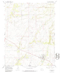
1964 Map of Dove Creek
USGS Topo · Published 1986About this map
Dove Creek serves as the primary hub of this high-plateau landscape in Dolores County, where mid-century agriculture and transportation infrastructure dominate the terrain. A clear network of canyons and draws, such as Wilson Draw and West Branch Canyon, defines the drainage patterns of the region, while a long-distance Pipeline cuts across the western sections. The town itself is well-developed for its size, featuring a Municipal Airport, a substantial Grain Elevator, and community amenities like an Athletic Field and a Drive-in Theater located just to the west. For those looking into family history, the Peel Cem and another local Cem provide important genealogical touchpoints. The presence of a Radio Facility and numerous survey markers indicates the area's role as a logistical and communication waypoint near the Utah state line.
Find a feature on this map
24 named features on this map. Tap any name to fly to it.
Don’t see what you’re looking for? This feature index may not catch every label — zoom into the map to look around manually.
Map Details
Editions of this 1964 Dove Creek Map
3 editions found
Other maps of this area

1886 · Abajo
USGS Topo · 1:250,000

1892 · Abajo
USGS Topo · 1:250,000

1893 · Abajo
USGS Topo · 1:250,000

1949 · Egnar
USGS Topo · 1:24,000

1949 · Joe Davis Hill
USGS Topo · 1:24,000

1950 · Joe Davis Hill
USGS Topo · 1:24,000

1950 · Egnar
USGS Topo · 1:24,000

1956 · Cortez
USGS Topo · 1:250,000

1957 · Cedar 3 NW
USGS Topo · 1:24,000

1957 · Monument Canyon
USGS Topo · 1:62,500