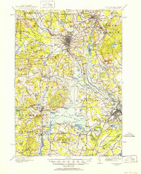
1916 Map of Dover
USGS Topo · Published 1952About this map
The confluence of the Cocheco River and the Bellamy River at Dover anchors this coastal-adjacent survey, which captures the bustling educational and industrial network along the Piscataqua River boundary. The State College at Durham is a prominent fixture, surrounded by numerous district schools such as the Mast Road School and Dover Point School. This era is defined by a dense intersection of transport, where the Boston and Maine RR and local Electric RR lines connected manufacturing hubs with more rural outposts like East Barrington and South Berwick.
Find a feature on this map
192 named features on this map. Tap any name to fly to it.
Don’t see what you’re looking for? This feature index may not catch every label — zoom into the map to look around manually.
Map Details
Editions of this 1916 Dover Map
2 editions found

Other maps of this area

1888 · Newburyport
USGS Topo · 1:62,500

1888 · Haverhill
USGS Topo · 1:62,500

1890 · Haverhill
USGS Topo · 1:62,500

1890 · Newburyport
USGS Topo · 1:62,500

1891 · Berwick
USGS Topo · 1:62,500

1891 · Kennebunk
USGS Topo · 1:62,500

1893 · Kennebunk
USGS Topo · 1:62,500

1893 · Dover
USGS Topo · 1:62,500

1893 · Berwick
USGS Topo · 1:62,500

1893 · York
USGS Topo · 1:62,500