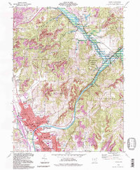
1994 Map of Dover
USGS Topo · Published 1998About this map
The Tuscarawas River valley in the mid-1990s reflects a landscape shaped by industrial heritage and water management, dominated by the major hubs of Dover and New Philadelphia. Evidence of the region's transport history remains visible through the Abandoned Canal running parallel to the river and the Dover Dam infrastructure. To the north, the historic village of Zoar sits near Zoar Lake, while Valley Junction marks a significant confluence where Conotton Creek meets the main river valley. This survey documents a high density of local institutions, from St Peters Ch and St Pauls Ch to established landmarks like the County Fairground and Tuscora Park. Industrial activity is noted through scattered Strip Mine and Gravel Pits locations, contrasting with the structured lands of the Muskingum Watershed Conservation District.
Find a feature on this map
56 named features on this map. Tap any name to fly to it.
Don’t see what you’re looking for? This feature index may not catch every label — zoom into the map to look around manually.
Map Details
Editions of this 1994 Dover Map
This is the sole edition of this map. No revisions or reprints were ever made.
Other maps of this area

1909 · Uhrichsville
USGS Topo · 1:62,500

1911 · Uhrichsville
USGS Topo · 1:62,500

1911 · Newcomerstown
USGS Topo · 1:62,500

1912 · Dover
USGS Topo · 1:62,500

1913 · Newcomerstown
USGS Topo · 1:62,500

1914 · Navarre
USGS Topo · 1:62,500

1943 · Newcomerstown
USGS Topo · 1:62,500

1944 · Navarre
USGS Topo · 1:62,500

1944 · Dover
USGS Topo · 1:62,500

1951 · Canton
USGS Topo · 1:250,000