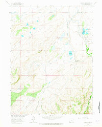
1963 Map of Downey Lakes
USGS Topo · Published 1965About this map
High-country water management and ranching define this Albany County landscape during the early 1960s. The terrain is shaped by a complex network of irrigation features designed to move water through the arid basins, including the King Ditch, Old King Ditch, and a prominent Aqueduct crossing the northern sections. Central to the area are the Downey Lakes and Steamboat Lake, while the local economy is anchored by established family operations such as the Hunzicker Ranch, Spring Creek Ranch, and Goetz Ranch.
Find a feature on this map
24 named features on this map. Tap any name to fly to it.
Don’t see what you’re looking for? This feature index may not catch every label — zoom into the map to look around manually.
Map Details
Editions of this 1963 Downey Lakes Map
2 editions found
Other maps of this area

1895 · Laramie
USGS Topo · 1:125,000

1902 · Laramie
USGS Topo · 1:125,000

1905 · Laramie
USGS Topo · 1:125,000

1906 · Laramie
USGS Topo · 1:125,000

1908 · Laramie
USGS Topo · 1:125,000

1916 · Home
USGS Topo · 1:125,000

1920 · Home
USGS Topo · 1:125,000

1954 · Cheyenne
USGS Topo · 1:250,000

1954 · Greeley
USGS Topo · 1:250,000

1957 · Greeley
USGS Topo · 1:250,000