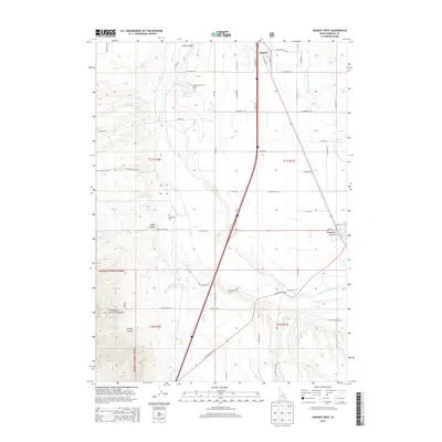
2013 Map of Downey West
USGS Topo · Published 2013About this map
Marsh Valley dominates this Idaho landscape, where the agricultural flats meet the rising slopes of the Caribou National Forest. The settlement of Virginia sits near the northern edge, while Downey anchors the southeast, connected by the corridor of S Highway 91 and modern transit lines. The local water management is evident through the Portneuf Marsh Valley Canal and the Wiregrass Reservoir, which includes a designated Wiregrass Reservoir Access Area. To the west, the terrain becomes more complex as the valley floor gives way to Mines Canyon and Rowley Canyon. Genealogists and local historians can find Woodland Cem positioned centrally between the hills and the valley floor, a quiet landmark amidst the grid of rural roads like W Chicken Flats Rd and Mines Canyon Rd.
Find a feature on this map
70 named features on this map. Tap any name to fly to it.
Don’t see what you’re looking for? This feature index may not catch every label — zoom into the map to look around manually.
Map Details
Editions of this 2013 Downey West Map
This is the sole edition of this map. No revisions or reprints were ever made.
Other maps of this area

1954 · Pocatello
USGS Topo · 1:250,000

1958 · Pocatello
USGS Topo · 1:250,000

1968 · Malad Summit
USGS Topo · 1:24,000

1968 · Oxford
USGS Topo · 1:24,000

1968 · Downey West
USGS Topo · 1:24,000

1968 · Wakley Peak
USGS Topo · 1:24,000
1968 · Downey East
USGS Topo · 1:24,000
1968 · Elkhorn Peak
USGS Topo · 1:24,000

1968 · Hawkins
USGS Topo · 1:24,000

1968 · Lava Hot Springs
USGS Topo · 1:24,000