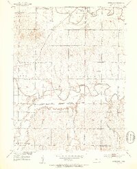
1953 Map of Downs South
USGS Topo · Published 1953About this map
The North Fork Solomon River and South Fork Solomon River converge toward the east in this mid-century survey of Osborne County. The town of Downs occupies the northern valley floor, supported by a sophisticated rail network including the Missouri Pacific and the Atchison Topeka and Santa Fe railroads. The landscape is structured by township boundaries such as Bethany, Ross, and Corinth, reflecting a settled agricultural district organized around local institutions. Rural life is anchored by landmarks like the Cottonwood Sch and High Prairie Sch, along with several community burial grounds including South Solomon Cem and Iowa Cem. Small outposts like Corinth and Forney sit along the rail lines, illustrating the importance of steam and diesel transport to the regional economy before the interstate era.
Find a feature on this map
22 named features on this map. Tap any name to fly to it.
Don’t see what you’re looking for? This feature index may not catch every label — zoom into the map to look around manually.
Map Details
Editions of this 1953 Downs South Map
3 editions found
Other maps of this area

1893 · Smith Center
USGS Topo · 1:125,000

1894 · Mankato
USGS Topo · 1:125,000

1894 · Beloit
USGS Topo · 1:125,000

1896 · Osborne
USGS Topo · 1:125,000

1953 · Downs South
USGS Topo · 1:24,000

1953 · Waconda Springs
USGS Topo · 1:24,000

1953 · Osborne
USGS Topo · 1:24,000

1955 · Beloit
USGS Topo · 1:250,000

1959 · Beloit
USGS Topo · 1:250,000

1960 · Downs North
USGS Topo · 1:24,000