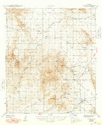
1943 Map of Dragoon
USGS Topo · Published 1948About this map
Allen Flat and the jagged peaks of the Winchester Mountains dominate this high-desert landscape during the early 1940s. The map reveals an economy driven by cattle ranching and hard-rock mining, with numerous family-named homesteads such as Bar X Ranch, Seven Dash Ranch, and Getzwiller Ranch scattered across the basin. In the mining district near Johnson Peak, several active operations are noted, including the Republic Mine and Keystone Mine, connected by a network of unimproved dirt roads. The southern portion of the sheet is anchored by the Southern Pacific railroad corridor, which snakes through Dragoon Pass and serves the settlement of Dragoon. Notable landmarks for the era include the Airway Beacon near Adams Peak and the Texas Canyon Sch, which served the rural community before modern consolidation changed the local education landscape.
Find a feature on this map
54 named features on this map. Tap any name to fly to it.
Don’t see what you’re looking for? This feature index may not catch every label — zoom into the map to look around manually.
Map Details
Editions of this 1943 Dragoon Map
3 editions found
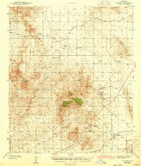
Other maps of this area

1915 · Benson
USGS Topo · 1:125,000

1916 · Pearce
USGS Topo · 1:125,000

1922 · Willcox
USGS Topo · 1:125,000

1922 · St. David
USGS Topo · 1:62,500

1926 · Whetstone
USGS Topo · 1:62,500

1926 · Courtland
USGS Topo · 1:62,500

1943 · Willcox
USGS Topo · 1:62,500

1943 · Benson
USGS Topo · 1:125,000

1943 · Cochise
USGS Topo · 1:62,500

1943 · Dragoon
USGS Topo · 1:62,500