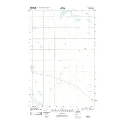
2011 Map of Drake
USGS Topo · Published 2011About this map
Drake serves as the primary hub of this McHenry County landscape, showing a structured grid of residential streets including Cedar St, Main St, and High St. The surrounding countryside follows a rigorous section-line road network, where the small settlements of Norfolk and Funston are situated near ephemeral water bodies and the larger Flat Lake to the north. This area reflects a deeply rooted community history, evidenced by the distribution of local burial grounds. Genealogists and historians will find notable landmarks such as Zion Cemetery, Sons of Herman Cemetery, and Saint Martins Cemetery positioned across the prairie, marking the legacy of early families and fraternal organizations in the region. The landscape is primarily defined by its agricultural layout, punctuated by the various section roads like 40th St NE and 10th Ave NE.
Find a feature on this map
29 named features on this map. Tap any name to fly to it.
Don’t see what you’re looking for? This feature index may not catch every label — zoom into the map to look around manually.
Map Details
Editions of this 2011 Drake Map
This is the sole edition of this map. No revisions or reprints were ever made.
Other maps of this area

1930 · Drake
USGS Topo · 1:62,500

1940 · Aylmer
USGS Topo · 1:62,500

1951 · Anamoose SW
USGS Topo · 1:24,000

1954 · Minot
USGS Topo · 1:250,000

1954 · McClusky
USGS Topo · 1:250,000

1957 · Rangeley SE
USGS Topo · 1:24,000

1957 · Rangeley
USGS Topo · 1:24,000

1958 · McClusky
USGS Topo · 1:250,000

1958 · Minot
USGS Topo · 1:250,000
1958 · Anamoose
USGS Topo · 1:24,000