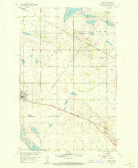
1958 Map of Drake
USGS Topo · Published 1959About this map
Drake serves as a central rail hub in the late 1950s, where the Minneapolis St Paul and Sault Ste Marie line meets the Great Northern railroad. The surrounding McHenry County prairie is organized into distinct townships including Strege, Schiller, Spring Grove, and Anamoose. This landscape is shaped by the shallow depression of Antelope Valley and the waters of Flat Lake, while the local social fabric is clearly visible through rural landmarks. Notable sites include several historic burial grounds such as Zion Cem, St Martins Cem, and the Sons of Herman Cem. While School No 1 appears active, the map notes that Roosevelt Sch No 1 had already ceased operation, reflecting shifting population patterns in these North Dakota farming communities.
Find a feature on this map
19 named features on this map. Tap any name to fly to it.
Don’t see what you’re looking for? This feature index may not catch every label — zoom into the map to look around manually.
Map Details
Editions of this 1958 Drake Map
This is the sole edition of this map. No revisions or reprints were ever made.
Other maps of this area

1930 · Drake
USGS Topo · 1:62,500

1940 · Aylmer
USGS Topo · 1:62,500

1951 · Anamoose SW
USGS Topo · 1:24,000

1954 · Minot
USGS Topo · 1:250,000

1954 · McClusky
USGS Topo · 1:250,000

1957 · Rangeley SE
USGS Topo · 1:24,000

1957 · Rangeley
USGS Topo · 1:24,000

1958 · McClusky
USGS Topo · 1:250,000

1958 · Minot
USGS Topo · 1:250,000
1958 · Anamoose
USGS Topo · 1:24,000