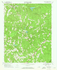
1968 Map of Drakes Branch
USGS Topo · Published 1972About this map
Drakes Branch serves as a central hub in this rural Charlotte County landscape, where the Southern railroad line cuts through the rolling terrain near Twittys Creek. The map documents a scattered community structure defined by small country churches and rural education centers, including Mt Calvary Ch, Organ Hill Ch, and the Bacon District Sch. Farther south, the transition between Horsepen Creek and Bluestone Creek reveals a topography of narrow valleys and winding stream branches, leading toward the South Meherrin River at the Mecklenburg County line.
Find a feature on this map
33 named features on this map. Tap any name to fly to it.
Don’t see what you’re looking for? This feature index may not catch every label — zoom into the map to look around manually.
Map Details
Editions of this 1968 Drakes Branch Map
3 editions found
Other maps of this area

1891 · Farmville
USGS Topo · 1:125,000

1892 · Appomattox
USGS Topo · 1:125,000

1893 · Farmville
USGS Topo · 1:125,000

1947 · Roanoke
USGS Topo · 1:250,000

1953 · Greensboro
USGS Topo · 1:250,000

1954 · Greensboro
USGS Topo · 1:250,000

1954 · Clover
USGS Topo · 1:62,500

1955 · Chase City
USGS Topo · 1:62,500

1956 · Charlotte Court House
USGS Topo · 1:62,500

1958 · Keysville
USGS Topo · 1:62,500