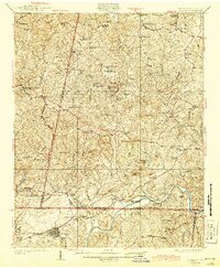
1926 Map of Draper
USGS Topo · Published 1944About this map
The Danville and Western Railroad cuts a diagonal path through the Piedmont landscape of the mid-1920s, connecting the scattered tobacco-growing communities along the Virginia and North Carolina border. This era is defined by its rural density, with a proliferation of neighborhood schools like Cranberry School and Hickory Grove School serving local farming families. The map captures a moment when mail and travel centered on multi-purpose rural hubs, evidenced by dual-named sites such as Oak Hill Sta Wenonda PO and Aiken Summit Limeoak PO.
Find a feature on this map
103 named features on this map. Tap any name to fly to it.
Don’t see what you’re looking for? This feature index may not catch every label — zoom into the map to look around manually.
Map Details
Editions of this 1926 Draper Map
3 editions found

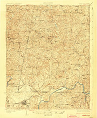
Other maps of this area

1921 · Chatham
USGS Topo · 1:48,000

1922 · Callands
USGS Topo · 1:48,000

1923 · Danville
USGS Topo · 1:48,000

1923 · Chatham
USGS Topo · 1:62,500

1924 · Martinsville
USGS Topo · 1:48,000

1924 · Draper
USGS Topo · 1:48,000

1924 · Callands
USGS Topo · 1:62,500

1925 · Rocky Mount
USGS Topo · 1:48,000

1925 · Danville
USGS Topo · 1:62,500

1926 · Martinsville
USGS Topo · 1:62,500