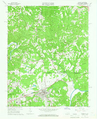
1965 Map of Draper
USGS Topo · Published 1966About this map
The Southern railroad corridor dictates the industrial and residential development of this borderland region in the mid-1960s, connecting the communities of Draper and Spray with the Leaksville Junction to the northeast. Near the state line, the landscape transitions from the concentrated street grids of the Central Area to the rural tobacco-growing terrain of Henry and Pittsylvania Counties. Evidence of the region's earlier river-based economy is preserved in labels like Old Ferry Rd and the Morgan Ford Bridge crossing the Smith River.
Find a feature on this map
57 named features on this map. Tap any name to fly to it.
Don’t see what you’re looking for? This feature index may not catch every label — zoom into the map to look around manually.
Map Details
Editions of this 1965 Draper Map
4 editions found
Other maps of this area

1924 · Martinsville
USGS Topo · 1:48,000

1924 · Draper
USGS Topo · 1:48,000

1926 · Martinsville
USGS Topo · 1:62,500

1926 · Draper
USGS Topo · 1:62,500

1927 · Martinsville
USGS Topo · 1:62,500

1944 · Martinsville
USGS Topo · 1:62,500

1944 · Draper
USGS Topo · 1:62,500

1953 · Greensboro
USGS Topo · 1:250,000

1954 · Greensboro
USGS Topo · 1:250,000

1962 · Greensboro
USGS Topo · 1:250,000