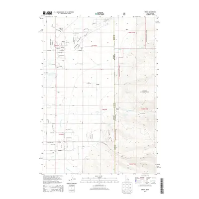
2013 Map of Driggs
USGS Topo · Published 2013About this map
Driggs serves as the focal point of this high-altitude landscape where the Teton Basin meets the rising slopes of the Targhee National Forest. The transition from the valley floor to the mountains is marked by an intricate network of irrigation and drainage, including Cherry Grove Canal and Kimball Canal, which supported the agricultural development of settlements like Darby and Chapin. The map documents a modern era of the valley, showing residential growth in areas like Teton Ranchettes alongside established local landmarks. Cultural and transit hubs are clearly visible, from the Driggs-Reed Memorial Airport in the north to the Spud Drive-In further south. The rugged eastern boundary is defined by the Idaho-Wyoming border, where the terrain climbs sharply into the forest towards features like Darby Canyon and Nelson Spring.
Find a feature on this map
112 named features on this map. Tap any name to fly to it.
Don’t see what you’re looking for? This feature index may not catch every label — zoom into the map to look around manually.
Map Details
Editions of this 2013 Driggs Map
This is the sole edition of this map. No revisions or reprints were ever made.
Other maps of this area

1899 · Grand Teton
USGS Topo · 1:125,000

1901 · Grand Teton
USGS Topo · 1:125,000

1943 · Driggs
USGS Topo · 1:62,500

1946 · Driggs
USGS Topo · 1:62,500

1955 · Driggs
USGS Topo · 1:250,000

1958 · Driggs
USGS Topo · 1:250,000

1962 · Driggs
USGS Topo · 1:250,000

1965 · Clawson
USGS Topo · 1:24,000
1965 · Tetonia
USGS Topo · 1:24,000
1968 · Granite Basin
USGS Topo · 1:24,000