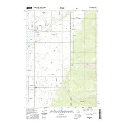
2017 Map of Driggs
USGS Topo · Published 2017About this map
The Driggs townsite sits at the heart of the Teton Basin, serving as a central hub for this high valley along the Idaho-Wyoming border. This 2017 study illustrates the intersection of small-town development and the immense wilderness of the Targhee National Forest, which dominates the eastern half of the map. Traces of the region's agricultural and civil foundations are evident in the Cherry Grove Canal and the Kimball Canal, critical water management features for the basin's ranching and farming operations. The landscape is a transition from the grid-patterned streets of the valley floor to the rising slopes of the Teton Range, marked by drainages like Darby Creek and Fox Creek. Local history is anchored by sites such as the Driggs-Darby Cemetery and the Driggs-Reed Memorial Airport, while smaller clusters of settlement are identified at Darby, Alta, and Chapin.
Find a feature on this map
132 named features on this map. Tap any name to fly to it.
Don’t see what you’re looking for? This feature index may not catch every label — zoom into the map to look around manually.
Map Details
Editions of this 2017 Driggs Map
This is the sole edition of this map. No revisions or reprints were ever made.
Other maps of this area

1899 · Grand Teton
USGS Topo · 1:125,000

1901 · Grand Teton
USGS Topo · 1:125,000

1943 · Driggs
USGS Topo · 1:62,500

1946 · Driggs
USGS Topo · 1:62,500

1955 · Driggs
USGS Topo · 1:250,000

1958 · Driggs
USGS Topo · 1:250,000

1962 · Driggs
USGS Topo · 1:250,000

1965 · Clawson
USGS Topo · 1:24,000
1965 · Tetonia
USGS Topo · 1:24,000
1968 · Granite Basin
USGS Topo · 1:24,000