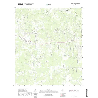
2019 Map of Dripping Springs
USGS Topo · Published 2019About this map
Dripping Springs serves as the focal point of this Central Texas landscape, situated where the Edwards Plateau begins its dramatic descent. The map reveals a transition from the structured residential developments near the town center to the sprawling ranch lands and deep limestone drainages that define the Hill Country. Significant water features such as Barton Cr and Onion Cr carve through the terrain, joined by smaller tributaries like Little Barton Cr and Jackson Br. These waterways historically dictated the location of early settlements and family burial grounds. Local genealogists will find several key sites preserved on this sheet, including the Fitzhugh Cem, Wallace Mountain Cem, and Phillips Cem. The mapping of small springs like Walnut Spring and Kirby Spring provides a detailed look at the hydrology that supported the rural communities of Fitzhugh and Driftwood long before modern infrastructure reached the area.
Find a feature on this map
155 named features on this map. Tap any name to fly to it.
Don’t see what you’re looking for? This feature index may not catch every label — zoom into the map to look around manually.
Map Details
Editions of this 2019 Dripping Springs Map
This is the sole edition of this map. No revisions or reprints were ever made.
Other maps of this area

1887 · Blanco
USGS Topo · 1:125,000

1894 · Blanco
USGS Topo · 1:125,000

1896 · Austin
USGS Topo · 1:125,000

1897 · Austin
USGS Topo · 1:125,000

1910 · Austin
USGS Topo · 1:125,000

1932 · Mt. Bonnell
USGS Topo · 1:62,500

1954 · Llano
USGS Topo · 1:250,000

1954 · Austin
USGS Topo · 1:250,000

1955 · Llano
USGS Topo · 1:250,000

1956 · Llano
USGS Topo · 1:250,000