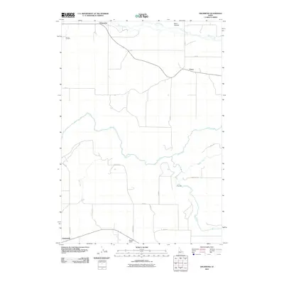
2010 Map of Drummond
USGS Topo · Published 2010About this map
Drummond sits at the northern edge of this high-plateau landscape, where the agricultural grid meets the deep incisions of the regional waterways. The map captures the small settlements of France and Clementsville connected by a network of rural routes including Linderman Rd and Anderson Rd. The drainage pattern is the dominant physical feature, with the Teton River winding through the center, joined by several tributaries including Milk Creek and the strikingly named Bitch Creek. This area illustrates the late 20th-century transition of Idaho's agricultural and water management systems. Evidence of local infrastructure is found at Felt Dam along the river, while the Farnum Cemetery provides a specific point of interest for genealogists tracing early families in Fremont County. To the north, Conant Creek flows past Henry Meadow, highlighting the mixture of riparian areas and cultivated fields that characterize this portion of the Snake River Plain.
Find a feature on this map
25 named features on this map. Tap any name to fly to it.
Don’t see what you’re looking for? This feature index may not catch every label — zoom into the map to look around manually.
Map Details
Editions of this 2010 Drummond Map
This is the sole edition of this map. No revisions or reprints were ever made.
Other maps of this area

1955 · Ashton
USGS Topo · 1:250,000

1955 · Driggs
USGS Topo · 1:250,000

1957 · Warm River Butte
USGS Topo · 1:62,500

1958 · Driggs
USGS Topo · 1:250,000

1958 · Ashton
USGS Topo · 1:250,000

1960 · Ashton
USGS Topo · 1:250,000

1962 · Driggs
USGS Topo · 1:250,000

1965 · Lamont
USGS Topo · 1:24,000

1965 · Ashton
USGS Topo · 1:24,000

1965 · Packsaddle Lake
USGS Topo · 1:24,000