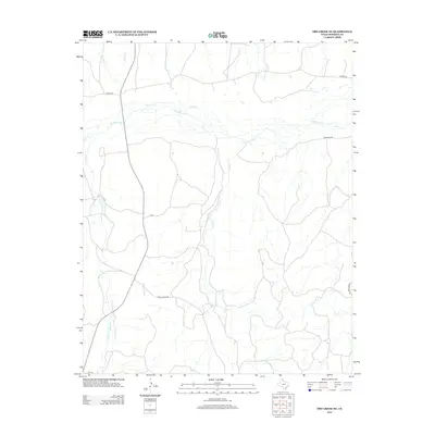
2012 Map of Dry Creek NE
USGS Topo · Published 2012About this map
The Canadian River cuts through this high plains landscape of Roberts County, carving out a network of drainage creeks in an otherwise sparse ranching region. This 2012 survey reveals the isolation of the Panhandle, where the namesake Red Windmill stands as one of the few named landmarks outside of the creek beds and ranch tracks. The drainage patterns of Dugout Cr, Sourdough Cr, and Indian Cr dominate the topography, illustrating the erosional forces that define the local geography. Transportation is limited to a handful of thoroughfares such as Ranch Road 283 and Payne Ranch Rd, which connect remote ranching operations. The map provides a clear look at the intersection of water rights and land use, where seasonal waterways like Chicken Cr and Dry Creek are the primary features in a land shaped by cattle and wind.
Find a feature on this map
13 named features on this map. Tap any name to fly to it.
Don’t see what you’re looking for? This feature index may not catch every label — zoom into the map to look around manually.
Map Details
Editions of this 2012 Dry Creek NE Map
This is the sole edition of this map. No revisions or reprints were ever made.
Other maps of this area

1954 · Perryton
USGS Topo · 1:250,000

1954 · Amarillo
USGS Topo · 1:250,000

1958 · Perryton
USGS Topo · 1:250,000

1958 · Amarillo
USGS Topo · 1:250,000

1971 · Dry Creek South
USGS Topo · 1:24,000

1971 · Dry Creek SE
USGS Topo · 1:24,000

1971 · Dry Creek NE
USGS Topo · 1:24,000

1971 · Dry Creek North
USGS Topo · 1:24,000

1972 · Horse Creek North
USGS Topo · 1:24,000
1972 · Horse Creek South
USGS Topo · 1:24,000