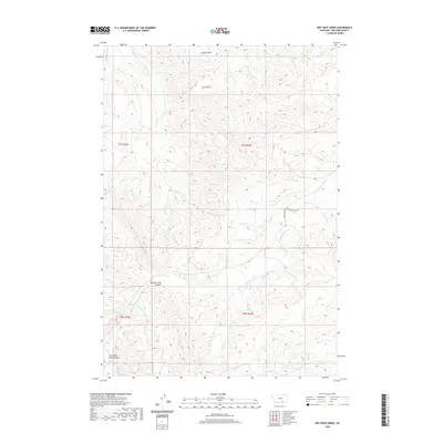
2020 Map of Dry Soap Creek
USGS Topo · Published 2020About this map
Rotten Grass Canyon dominates the southern landscape of this Big Horn County territory, where deep drainages and high basins define the geography. The map reveals a complex network of seasonal and perennial waterways including Dry Soap Cr in the north and the descriptively named Packs The Hat Cr further south. This 2020 survey illustrates a sparsely populated region of Montana where transportation is limited to rugged paths like Good Luck Rd and Rotten Grass Crk Rd. The terrain is marked by significant elevation changes, with named landforms such as Ash Coulee, Christmas Tree Coulee, and Cooper Basin providing essential landmarks for navigation and land management in the absence of established towns or settlements.
Find a feature on this map
14 named features on this map. Tap any name to fly to it.
Don’t see what you’re looking for? This feature index may not catch every label — zoom into the map to look around manually.
Map Details
Editions of this 2020 Dry Soap Creek Map
This is the sole edition of this map. No revisions or reprints were ever made.
Other maps of this area

1894 · St. Xavier
USGS Topo · 1:125,000

1901 · St. Xavier
USGS Topo · 1:125,000

1954 · Hardin
USGS Topo · 1:250,000

1957 · Hardin
USGS Topo · 1:250,000

1958 · Hardin
USGS Topo · 1:250,000

1960 · Schick Ranch
USGS Topo · 1:24,000

1960 · Mission Coulee
USGS Topo · 1:24,000
1964 · Mountain Pocket Creek
USGS Topo · 1:24,000
1969 · Willow Creek Dam SW
USGS Topo · 1:24,000
1969 · Black Gulch
USGS Topo · 1:24,000