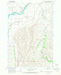
1964 Map of Mountain Pocket Creek
USGS Topo · Published 1967About this map
The Bighorn River cuts through the northern reaches of this landscape, its path shaped by a complex network of man-made irrigation and natural drainage during the mid-1960s. Located entirely within the Crow Indian Reservation, the terrain transitions from the river valley into upland territory marked by the Soap Creek Field, indicating the importance of local energy resources to the area's economy. The intricate water system is defined by a series of canals, a Flowing Well, and a Gaging Sta, reflecting a managed landscape where water rights and flow were meticulously monitored for agriculture and industry.
Find a feature on this map
15 named features on this map. Tap any name to fly to it.
Don’t see what you’re looking for? This feature index may not catch every label — zoom into the map to look around manually.
Map Details
Editions of this 1964 Mountain Pocket Creek Map
2 editions found
Other maps of this area

1894 · St. Xavier
USGS Topo · 1:125,000

1901 · St. Xavier
USGS Topo · 1:125,000

1915 · Spenceville
USGS Topo · 1:31,680

1954 · Hardin
USGS Topo · 1:250,000

1957 · Hardin
USGS Topo · 1:250,000

1958 · Hardin
USGS Topo · 1:250,000

1960 · St Xavier
USGS Topo · 1:24,000

1960 · Mission Coulee
USGS Topo · 1:24,000

1964 · Peyote Point
USGS Topo · 1:24,000
1964 · Yellowtail Dam
USGS Topo · 1:24,000