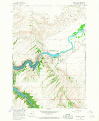
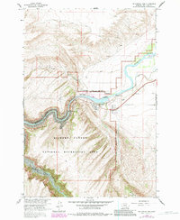
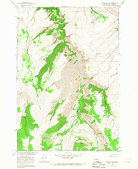
1964 Map of Yellowtail Dam
USGS Topo · Published 1967About this map
Yellowtail Dam stands as the central engineering marvel of this mid-1960s landscape, holding back the waters of the Yellowtail Reservoir as it snakes through Bighorn Canyon. This era represents a significant transformation of the Bighorn River valley, where newly established infrastructure like the Yellowtail Afterbay Dam, a Substation, and Sewage Disposal Ponds contrast with the area's deeper history. The presence of the Fort Smith Ruins near the modern settlement of Fort Smith highlights the strategic importance of this river crossing over time.
Find a feature on this map
23 named features on this map. Tap any name to fly to it.
Don’t see what you’re looking for? This feature index may not catch every label — zoom into the map to look around manually.
Map Details
Editions of this 1964 Yellowtail Dam Map
2 editions found
Other maps of this area

1894 · St. Xavier
USGS Topo · 1:125,000

1901 · St. Xavier
USGS Topo · 1:125,000

1915 · Spenceville
USGS Topo · 1:31,680

1954 · Billings
USGS Topo · 1:250,000

1954 · Hardin
USGS Topo · 1:250,000

1957 · Hardin
USGS Topo · 1:250,000

1957 · Billings
USGS Topo · 1:250,000

1958 · Billings
USGS Topo · 1:250,000

1958 · Hardin
USGS Topo · 1:250,000
1964 · Peyote Point
USGS Topo · 1:24,000