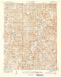
1943 Map of Drynob
USGS Topo · Published 1943About this map
The Gasconade River and Roubidoux Creek wind through the Ozark plateau in this 1943 survey, revealing a landscape defined by water crossings and small, self-sufficient communities. The eastern edge of the map is dominated by the Fort Leonard Wood Military Reservation, which was established shortly before this edition was published. Throughout the Laclede County interior, numerous river crossings such as Adam Ford, Casey Ford, and Bougan Bridge indicate the essential role of the river in local transportation. Small commerce hubs like Winter Store and Moola Store served the surrounding farmsteads. Notable for genealogists are the diverse rural burial grounds, including the Winnipeg Cems and Nicks Cem, and the high density of small schoolhouses like Morehouse Sch and Stockdale Sch that once anchored these Ozark hollows.
Find a feature on this map
80 named features on this map. Tap any name to fly to it.
Don’t see what you’re looking for? This feature index may not catch every label — zoom into the map to look around manually.
Map Details
Editions of this 1943 Drynob Map
3 editions found

Other maps of this area

1931 · Manes
USGS Topo · 1:48,000

1933 · Stoutland
USGS Topo · 1:62,500

1936 · Waynesville
USGS Topo · 1:48,000

1938 · Stoutland
USGS Topo · 1:62,500

1941 · Big Piney
USGS Topo · 1:62,500

1941 · Manes
USGS Topo · 1:62,500

1941 · Lebanon
USGS Topo · 1:62,500

1941 · Bado
USGS Topo · 1:62,500

1942 · Waynesville
USGS Topo · 1:62,500

1943 · Richland
USGS Topo · 1:62,500