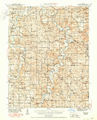
1943 Map of Drynob
USGS Topo · Published 1950About this map
The Gasconade River winds through this Ozark landscape, carving a deep valley that dictates the region's transport and settlement patterns. To the east, the Fort Leonard Wood Military Reservation and the Mark Twain National Forest cover significant territory, marking the transition from agricultural homesteads to federal land management. Local life in the early 1940s centered around small crossroads communities like Drynob, Falcon, and Winnipeg, each supporting a network of country schools such as Oakland Sch and Harmony Sch.
Find a feature on this map
108 named features on this map. Tap any name to fly to it.
Don’t see what you’re looking for? This feature index may not catch every label — zoom into the map to look around manually.
Map Details
Editions of this 1943 Drynob Map
3 editions found

Other maps of this area

1931 · Manes
USGS Topo · 1:48,000

1933 · Stoutland
USGS Topo · 1:62,500

1936 · Waynesville
USGS Topo · 1:48,000

1938 · Stoutland
USGS Topo · 1:62,500

1941 · Big Piney
USGS Topo · 1:62,500

1941 · Manes
USGS Topo · 1:62,500

1941 · Lebanon
USGS Topo · 1:62,500

1941 · Bado
USGS Topo · 1:62,500

1942 · Waynesville
USGS Topo · 1:62,500

1943 · Richland
USGS Topo · 1:62,500