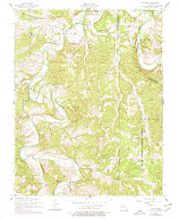
1954 Map of Drynob
USGS Topo · Published 1977About this map
Osage Fork and the Gasconade River dominate this Ozark landscape, carving through the township boundaries of Smith, Liberty, and Osage. This 1954 survey, updated with 1976 photorevisions, documents a rural landscape defined by narrow hollows and ridge-top homesteads. The small settlement of Drynob serves as a local anchor in the southern portion of the map, while numerous country landmarks speak to the area's genealogical depth.
Find a feature on this map
35 named features on this map. Tap any name to fly to it.
Don’t see what you’re looking for? This feature index may not catch every label — zoom into the map to look around manually.
Map Details
Editions of this 1954 Drynob Map
2 editions found
Other maps of this area

1933 · Stoutland
USGS Topo · 1:62,500

1938 · Stoutland
USGS Topo · 1:62,500

1941 · Lebanon
USGS Topo · 1:62,500

1943 · Richland
USGS Topo · 1:62,500

1943 · Lebanon
USGS Topo · 1:62,500

1943 · Drynob
USGS Topo · 1:62,500

1954 · Springfield
USGS Topo · 1:250,000

1954 · Drynob
USGS Topo · 1:62,500
1954 · Richland
USGS Topo · 1:62,500

1954 · Drew
USGS Topo · 1:24,000