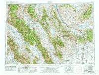
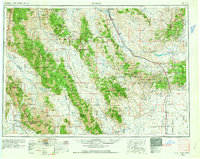
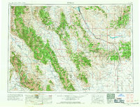
1955 Map of Dubois
USGS Topo · Published 1978About this map
The Continental Divide zigzags across this high-country landscape, defining the rugged border between Idaho and Montana during the mid-1950s. The Union Pacific railroad serves as the primary corridor for commerce and travel, connecting small mountain settlements like Monida, Spencer, and Dubois. This region is a complex of high peaks and protected lands, featuring the massive Lost River Range and Lemhi Range, which include notable summits like Borah Peak and Leatherman Peak.
Find a feature on this map
61 named features on this map. Tap any name to fly to it.
Don’t see what you’re looking for? This feature index may not catch every label — zoom into the map to look around manually.
Map Details
Editions of this 1955 Dubois Map
4 editions found

Other maps of this area

1888 · Three Forks
USGS Topo · 1:250,000

1893 · Dillon
USGS Topo · 1:250,000

1894 · Three Forks
USGS Topo · 1:250,000

1895 · Three Forks
USGS Topo · 1:250,000

1895 · Hailey
USGS Topo · 1:125,000

1897 · Hailey
USGS Topo · 1:125,000

1929 · Bayhorse
USGS Topo · 1:125,000

1935 · MacKay
USGS Topo · 1:96,000

1935 · Borah Peak
USGS Topo · 1:125,000

1938 · Borah Peak
USGS Topo · 1:125,000