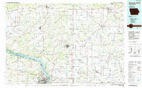
1984 Map of Dubuque North
USGS Topo · Published 1985About this map
Military Ridge defines the northern reaches of this Tri-State area, where the borders of Iowa, Wisconsin, and Illinois converge along the Mississippi River. The landscape is etched by the intricate drainages of the Grant River, Platte River, and Galena River, highlighting a region historically vital for its mineral wealth. A dense concentration of lead and zinc workings, including the Annie Mine, Basque Mine, and Liberty Mine, reveals the industrial heritage that once drove local economies in and around Platteville and Shullsburg. Along the riverbanks, the Upper Mississippi River Wild Life and Fish Refuge contrasts with the urban development of Dubuque, where landmarks like Clarke College and Loras College appear. The map also traces the era's rail network, featuring the Illinois Central Gulf and Burlington Northern railroads as they navigate the ridges and river bluffs.
Find a feature on this map
242 named features on this map. Tap any name to fly to it.
Don’t see what you’re looking for? This feature index may not catch every label — zoom into the map to look around manually.
Map Details
Editions of this 1984 Dubuque North Map
2 editions found
Other maps of this area

1900 · Anamosa
USGS Topo · 1:125,000

1900 · Lancaster
USGS Topo · 1:125,000

1901 · Peosta
USGS Topo · 1:125,000

1902 · Mineral Point
USGS Topo · 1:125,000

1902 · Elkader
USGS Topo · 1:125,000

1903 · Waukon
USGS Topo · 1:125,000

1904 · Lancaster
USGS Topo · 1:125,000

1905 · Richland Center
USGS Topo · 1:125,000

1908 · Lancaster
USGS Topo · 1:125,000

1911 · Elizabeth
USGS Topo · 1:62,500