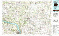
1984 Map of Dubuque North
USGS Topo · Published 1989About this map
The Mississippi River and its wide, braided channels dominate the western landscape of this mid-1980s regional survey, carving a path through the Upper Mississippi River Wild Life and Fish Refuge. To the east, the terrain transitions into a dense network of ridges and river valleys, including Mount Hope Ridge and the Grant River basin. The area's deep history of extraction is evident in the cluster of mining sites near the southern border, such as Liberty Mine, Meekers Grove, and Lead Mine.
Find a feature on this map
111 named features on this map. Tap any name to fly to it.
Don’t see what you’re looking for? This feature index may not catch every label — zoom into the map to look around manually.
Map Details
Editions of this 1984 Dubuque North Map
2 editions found
Other maps of this area

1900 · Anamosa
USGS Topo · 1:125,000

1900 · Lancaster
USGS Topo · 1:125,000

1901 · Peosta
USGS Topo · 1:125,000

1902 · Mineral Point
USGS Topo · 1:125,000

1902 · Elkader
USGS Topo · 1:125,000

1903 · Waukon
USGS Topo · 1:125,000

1904 · Lancaster
USGS Topo · 1:125,000

1905 · Richland Center
USGS Topo · 1:125,000

1908 · Lancaster
USGS Topo · 1:125,000

1911 · Elizabeth
USGS Topo · 1:62,500