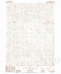
1986 Map of Duck Lake SE
USGS Topo · Published 1986About this map
The border between Cherry Co Thomas Co divides the landscape of the Nebraska Sandhills on this 1986 survey. The terrain is defined by a dense network of closed-depression wetlands and small prairie lakes, illustrating the unique hydrology of the region before modern land-use changes. Human infrastructure is notably sparse across this portion of Thomas County, consisting primarily of isolated Well locations and a prominent Radio Tower in the south. This map provides a detailed view of the natural topography and primitive road network as it existed during the mid-1980s, preserving a record of the remote ranching country and the intricate drainage patterns of the northern Sandhills.
Find a feature on this map
3 named features on this map. Tap any name to fly to it.
Don’t see what you’re looking for? This feature index may not catch every label — zoom into the map to look around manually.
Map Details
Editions of this 1986 Duck Lake SE Map
This is the sole edition of this map. No revisions or reprints were ever made.
Other maps of this area

1948 · Thedford
USGS Topo · 1:62,500

1948 · Halsey
USGS Topo · 1:62,500

1948 · Seneca 4
USGS Topo · 1:62,500

1949 · Seneca 4
USGS Topo · 1:62,500

1949 · Purdum
USGS Topo · 1:62,500

1950 · Thedford
USGS Topo · 1:62,500

1950 · Halsey
USGS Topo · 1:62,500

1951 · Purdum
USGS Topo · 1:62,500

1954 · North Platte
USGS Topo · 1:250,000

1956 · North Platte
USGS Topo · 1:250,000