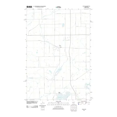
2010 Map of Duelm
USGS Topo · Published 2010About this map
The small settlement of Duelm serves as the focal point of this Benton County landscape, situated at the intersection of local routes like Duelm Rd Ne. The area's geography is defined by a network of slow-moving water, including the winding Stony Brook and Briggs Creek, which connect several significant water bodies such as Rice Lake and Briggs Lake. To the north of the main settlement, Saint Lawrence Cemetery stands as a primary landmark for genealogical research. The map reveals a highly structured grid of section roads, including historically named corridors like School House Rd Ne, indicating the long-standing agricultural and residential organization of Saint George Township. The southern portion of the quadrangle shows more concentrated development near the shores of Briggs Lake and Boyd Lake, where the local road network becomes more dense around 42nd St and 47th St.
Find a feature on this map
25 named features on this map. Tap any name to fly to it.
Don’t see what you’re looking for? This feature index may not catch every label — zoom into the map to look around manually.
Map Details
Editions of this 2010 Duelm Map
This is the sole edition of this map. No revisions or reprints were ever made.
Other maps of this area

1950 · St. Cloud
USGS Topo · 1:62,500

1951 · Annandale
USGS Topo · 1:62,500

1953 · Saint Cloud
USGS Topo · 1:250,000

1953 · Stillwater
USGS Topo · 1:250,000

1955 · Stillwater
USGS Topo · 1:250,000

1957 · Saint Cloud
USGS Topo · 1:250,000

1958 · Stillwater
USGS Topo · 1:250,000

1958 · Saint Cloud
USGS Topo · 1:250,000

1961 · Clear Lake
USGS Topo · 1:24,000

1961 · Becker
USGS Topo · 1:24,000