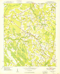
1949 Map of Duford
USGS Topo · Published 1949About this map
Gap Way Swamp and a series of elliptical depressions known as Carolina Bays define the landscape of the South Carolina-North Carolina border during the late 1940s. The settlement at Duford serves as a central point, anchored by Floyds High Sch and the Pee Dee Academy. The Atlantic Coast Line railroad cuts across the northern terrain, connecting rural communities like Floyds Crossroads to wider regional markets.
Find a feature on this map
63 named features on this map. Tap any name to fly to it.
Don’t see what you’re looking for? This feature index may not catch every label — zoom into the map to look around manually.
Map Details
Editions of this 1949 Duford Map
4 editions found
Other maps of this area

1943 · Pages Mill
USGS Topo · 1:62,500

1948 · Galivants Ferry
USGS Topo · 1:24,000

1948 · Nichols
USGS Topo · 1:24,000

1948 · Bayboro
USGS Topo · 1:24,000

1949 · Bayboro
USGS Topo · 1:24,000

1949 · Duford
USGS Topo · 1:24,000

1950 · Galivants Ferry
USGS Topo · 1:24,000

1950 · Nichols
USGS Topo · 1:24,000

1953 · Chadbourn
USGS Topo · 1:62,500

1953 · Florence
USGS Topo · 1:250,000