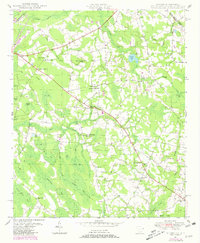
1949 Map of Duford
USGS Topo · Published 1981About this map
Duford and Floyds Crossroads anchor this rural landscape in Horry County during the mid-20th century, where the local economy and social life are clearly delineated by a network of country schools and churches. The map highlights the transition from traditional planetable topography to modern aerial revisions, capturing a terrain defined by distinctive "bays" or elliptical depressions such as Big Bay, Alligator Bay, and Cartwheel Bay. These wetland features, interspersed with drainages like Gapway Swamp and Jordan Creek, dictated the placement of early settlements and family cemeteries.
Find a feature on this map
63 named features on this map. Tap any name to fly to it.
Don’t see what you’re looking for? This feature index may not catch every label — zoom into the map to look around manually.
Map Details
Editions of this 1949 Duford Map
4 editions found
Other maps of this area

1943 · Pages Mill
USGS Topo · 1:62,500

1948 · Galivants Ferry
USGS Topo · 1:24,000

1948 · Nichols
USGS Topo · 1:24,000

1948 · Bayboro
USGS Topo · 1:24,000

1949 · Bayboro
USGS Topo · 1:24,000

1949 · Duford
USGS Topo · 1:24,000

1950 · Galivants Ferry
USGS Topo · 1:24,000

1950 · Nichols
USGS Topo · 1:24,000

1953 · Chadbourn
USGS Topo · 1:62,500

1953 · Florence
USGS Topo · 1:250,000