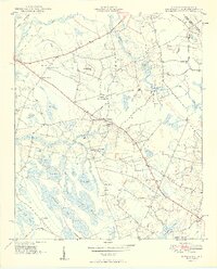
1949 Map of Duford
USGS Topo · Published 1949About this map
The Carolina borderlands in Horry County come to life in this mid-century survey, defined by the unique elliptical depressions known as Carolina Bays. Landforms such as Fifteenmile Bay, Cartwheel Bay, and Alligator Bay dictate the settlement patterns of the era, pushing homes and agriculture to the higher ground between these wet basins. The small community of Duford serves as a local hub, supported by the Floyds High Sch and nearby Pee Dee Academy. Transportation and commerce are anchored by the Atlantic Coast Line railroad cutting through the northwest corner, while numerous family-named landmarks like Riverside Cem and Granger Cem provide a dense map of post-war rural life. The landscape is a network of branches and swamps, including Gap Way Swamp and Hook Branch, which separate the various family-named churches like Martins Chapel Sch and Mt Vernon Ch that once anchored these remote South Carolina neighborhoods.
Find a feature on this map
69 named features on this map. Tap any name to fly to it.
Don’t see what you’re looking for? This feature index may not catch every label — zoom into the map to look around manually.
Map Details
Editions of this 1949 Duford Map
4 editions found
Other maps of this area

1943 · Pages Mill
USGS Topo · 1:62,500

1948 · Galivants Ferry
USGS Topo · 1:24,000

1948 · Nichols
USGS Topo · 1:24,000

1948 · Bayboro
USGS Topo · 1:24,000

1949 · Bayboro
USGS Topo · 1:24,000

1949 · Duford
USGS Topo · 1:24,000

1950 · Galivants Ferry
USGS Topo · 1:24,000

1950 · Nichols
USGS Topo · 1:24,000

1953 · Chadbourn
USGS Topo · 1:62,500

1953 · Florence
USGS Topo · 1:250,000