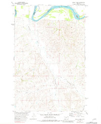
1969 Map of Dugout Creek
USGS Topo · Published 1981About this map
The Missouri River flows across the northern edge of this landscape, marking the boundary between Roosevelt and Richland counties. Much of the northern terrain falls within the Fort Peck Indian Res, where the river's path is carved through high bluffs. The interior is defined by a network of seasonal drainages, most notably Hardscrabble Creek, which winds its way toward the river alongside its tributary, East Hardscrabble Creek. In the southern portion of the sheet, Dugout Creek and Goodman Coulee shape the land, highlighting a region largely used for ranching and resource extraction during the late 1960s.
Find a feature on this map
11 named features on this map. Tap any name to fly to it.
Don’t see what you’re looking for? This feature index may not catch every label — zoom into the map to look around manually.
Map Details
Editions of this 1969 Dugout Creek Map
3 editions found

Other maps of this area

1909 · Glendive
USGS Topo · 1:250,000

1948 · Fort Kipp
USGS Topo · 1:24,000

1949 · Fort Kipp
USGS Topo · 1:24,000

1954 · Glendive
USGS Topo · 1:250,000

1954 · Wolf Point
USGS Topo · 1:250,000

1957 · Glendive
USGS Topo · 1:250,000

1958 · Wolf Point
USGS Topo · 1:250,000

1958 · Glendive
USGS Topo · 1:250,000
1969 · Culbertson
USGS Topo · 1:24,000
1969 · Twomile Creek
USGS Topo · 1:24,000