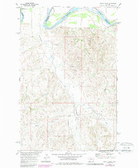
1969 Map of Dugout Creek
USGS Topo · Published 1989About this map
The Missouri River cuts across the northern edge of this landscape, marking a significant transition between the Fort Peck Indian Reservation and the surrounding terrain of Roosevelt and Richland counties. The topography is defined by an intricate network of drainage systems, including Hardscrabble Creek and its tributary East Hardscrabble Creek, which carve deep paths through the high plains. A clear sense of the 1960s industrial footprint is visible through symbols for a local Mine and scattered Oil Well sites, indicating the extraction activity that helped sustain this corner of Montana. The land south of the river, including Dugout Creek and Goodman Coulee, remains largely open and characterized by isolated landmarks like the lone Boulder standing in section 19.
Find a feature on this map
12 named features on this map. Tap any name to fly to it.
Don’t see what you’re looking for? This feature index may not catch every label — zoom into the map to look around manually.
Map Details
Editions of this 1969 Dugout Creek Map
3 editions found

Other maps of this area

1909 · Glendive
USGS Topo · 1:250,000

1948 · Fort Kipp
USGS Topo · 1:24,000

1949 · Fort Kipp
USGS Topo · 1:24,000

1954 · Glendive
USGS Topo · 1:250,000

1954 · Wolf Point
USGS Topo · 1:250,000

1957 · Glendive
USGS Topo · 1:250,000

1958 · Wolf Point
USGS Topo · 1:250,000

1958 · Glendive
USGS Topo · 1:250,000
1969 · Culbertson
USGS Topo · 1:24,000
1969 · Twomile Creek
USGS Topo · 1:24,000