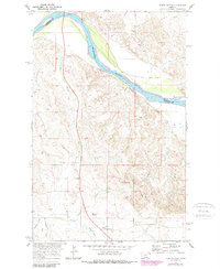
1969 Map of Three Buttes
USGS Topo · Published 1989About this map
The Missouri River winds along the northern boundary of this landscape, marking the transition between Roosevelt and Richland counties. This 1969 field-checked survey, updated in the 1980s, reveals a terrain defined by complex drainages and local landmarks such as Three Buttes and the curiously named Big Enough elevation. The survey depicts a vital stretch of the river near a Gaging Sta, where seasonal changes are tracked against the surrounding breaks and coulees.
Find a feature on this map
16 named features on this map. Tap any name to fly to it.
Don’t see what you’re looking for? This feature index may not catch every label — zoom into the map to look around manually.
Map Details
Editions of this 1969 Three Buttes Map
2 editions found
Other maps of this area

1909 · Glendive
USGS Topo · 1:250,000

1954 · Glendive
USGS Topo · 1:250,000

1954 · Wolf Point
USGS Topo · 1:250,000

1957 · Glendive
USGS Topo · 1:250,000

1958 · Wolf Point
USGS Topo · 1:250,000

1958 · Glendive
USGS Topo · 1:250,000

1969 · Cedar Coulee
USGS Topo · 1:24,000
1969 · Culbertson
USGS Topo · 1:24,000

1969 · Three Buttes
USGS Topo · 1:24,000

1969 · Dugout Creek
USGS Topo · 1:24,000