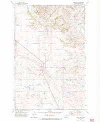
1972 Map of Sioux Pass
USGS Topo · Published 1975About this map
Sioux Pass serves as the central hub of this eastern Montana landscape, where the primary roadway cuts through the undulating terrain of Richland County. The small community is marked by its Town Hall and a nearby Substa, serving the surrounding agricultural and ranching operations. The geography is defined by a network of seasonal watercourses and coulees, most notably Cedar Coulee to the north and the winding drainage of Fourmile Creek.
Find a feature on this map
15 named features on this map. Tap any name to fly to it.
Don’t see what you’re looking for? This feature index may not catch every label — zoom into the map to look around manually.
Map Details
Editions of this 1972 Sioux Pass Map
This is the sole edition of this map. No revisions or reprints were ever made.
Other maps of this area

1909 · Glendive
USGS Topo · 1:250,000

1954 · Glendive
USGS Topo · 1:250,000

1954 · Wolf Point
USGS Topo · 1:250,000

1957 · Glendive
USGS Topo · 1:250,000

1958 · Wolf Point
USGS Topo · 1:250,000

1958 · Glendive
USGS Topo · 1:250,000

1969 · Cedar Coulee
USGS Topo · 1:24,000

1969 · Three Buttes
USGS Topo · 1:24,000

1969 · Bainville SW
USGS Topo · 1:24,000

1972 · Brorson
USGS Topo · 1:24,000