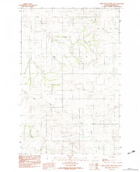
1983 Map of Three Buttes Creek East
USGS Topo · Published 1983About this map
Three Buttes Creek and its tributaries define this corner of Richland County in the early 1980s. The landscape is characterized by its drainage network, with the eponymous Three Buttes Creek winding through the southern sections while Charlie Creek and Timber Creek cut through the northern reaches. Evidence of rural infrastructure is found in the scattering of grain bins and isolated structures that dot the high ground between the watercourses. Social and industrial history is captured in small but significant markers, including a local Cem and several Gravel Pits that suggest local road maintenance and construction activity. The map provides a detailed look at the section lines and township boundaries, such as the divide between T 24 N and T 23 N, which is essential for researchers tracking land ownership and property history in this part of the Great Plains.
Find a feature on this map
9 named features on this map. Tap any name to fly to it.
Don’t see what you’re looking for? This feature index may not catch every label — zoom into the map to look around manually.
Map Details
Editions of this 1983 Three Buttes Creek East Map
This is the sole edition of this map. No revisions or reprints were ever made.
Other maps of this area

1909 · Glendive
USGS Topo · 1:250,000

1954 · Glendive
USGS Topo · 1:250,000

1957 · Glendive
USGS Topo · 1:250,000

1958 · Glendive
USGS Topo · 1:250,000

1966 · Crane NW
USGS Topo · 1:24,000

1972 · Girard
USGS Topo · 1:24,000
1972 · Blue Hill
USGS Topo · 1:24,000

1972 · Fox Lake
USGS Topo · 1:24,000

1972 · Lambert
USGS Topo · 1:24,000

1981 · Sidney
USGS Topo · 1:100,000