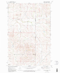
1974 Map of Skaar NE
USGS Topo · Published 1977About this map
Shadwell Sch and Grace Ch anchor this prairie landscape along the border of Montana and North Dakota. In the mid-1970s, this area where Richland, McKenzie, and Wibaux counties converge was defined by scattered water sources and topographical landmarks like Bull Butte. The terrain is marked by the drainages of Shadwell Creek and Poison Spring Creek, which provided essential water in an otherwise arid ranching and farming region. Small-scale industrial activity is evident through the presence of a Scoria Pit, a common feature in this part of the Great Plains where baked clay was harvested for road surfacing. Numerous wells dotted across the quadrangle highlight the ongoing importance of subterranean water access for the rural homesteads that persisted in this remote tri-county corner during the late twentieth century.
Find a feature on this map
12 named features on this map. Tap any name to fly to it.
Don’t see what you’re looking for? This feature index may not catch every label — zoom into the map to look around manually.
Map Details
Editions of this 1974 Skaar NE Map
2 editions found
Other maps of this area

1909 · Glendive
USGS Topo · 1:250,000

1953 · Watford City
USGS Topo · 1:250,000

1954 · Glendive
USGS Topo · 1:250,000

1957 · Glendive
USGS Topo · 1:250,000

1957 · Watford City
USGS Topo · 1:250,000

1958 · Glendive
USGS Topo · 1:250,000

1966 · Piche
USGS Topo · 1:24,000

1966 · Skaar NW
USGS Topo · 1:24,000

1967 · Watford City
USGS Topo · 1:250,000

1972 · Sidney SE
USGS Topo · 1:24,000