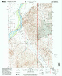
1997 Map of Sidney NE
USGS Topo · Published 2001About this map
The Yellowstone River cuts through the western edge of this landscape, where the state boundary separates Richland County, Montana, from McKenzie County, North Dakota. This 1990s revision reveals a region defined by the Little Missouri National Grassland and the distinctive topography of the Missouri River Breaks. Local infrastructure supports both agriculture and industry, with features such as the East Sidney Substation, multiple gas plants, and a Pumping Station situated near the riverbanks.
Find a feature on this map
23 named features on this map. Tap any name to fly to it.
Don’t see what you’re looking for? This feature index may not catch every label — zoom into the map to look around manually.
Map Details
Editions of this 1997 Sidney NE Map
This is the sole edition of this map. No revisions or reprints were ever made.
Other maps of this area

1909 · Glendive
USGS Topo · 1:250,000

1953 · Watford City
USGS Topo · 1:250,000

1954 · Glendive
USGS Topo · 1:250,000

1957 · Glendive
USGS Topo · 1:250,000

1957 · Watford City
USGS Topo · 1:250,000

1958 · Glendive
USGS Topo · 1:250,000

1966 · Piche
USGS Topo · 1:24,000

1966 · Sidney NE
USGS Topo · 1:24,000

1966 · Sidney
USGS Topo · 1:24,000

1967 · Watford City
USGS Topo · 1:250,000