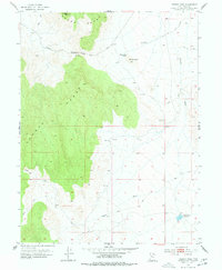
1953 Map of Dugway Pass
USGS Topo · Published 1978About this map
The Pony Express Route cuts across the high desert terrain of the Dugway Range in this 1953 survey, marking a corridor of historical significance in the Great Basin. This desert landscape is defined by the elevation of Pyramid Peak and the critical transition at Dugway Pass, where travelers once navigated between the rugged peaks of the Thomas Range and the open flats of Pismire Wash. The placement of the Dugway Pony Express Sta serves as a tangible reminder of the mid-19th-century mail service that briefly connected the coasts through this arid environment. Water management is evident through features like Bittner Knoll Res and East Topaz 2 Reservoir, highlighting the efforts to sustain activity in a region dominated by seasonal drainages like the North Fork and South Fork.
Find a feature on this map
15 named features on this map. Tap any name to fly to it.
Don’t see what you’re looking for? This feature index may not catch every label — zoom into the map to look around manually.
Map Details
Editions of this 1953 Dugway Pass Map
3 editions found
Other maps of this area

1885 · Sevier Desert
USGS Topo · 1:250,000

1908 · Fish Springs
USGS Topo · 1:250,000

1910 · Fish Springs
USGS Topo · 1:250,000

1953 · Dugway Range NE
USGS Topo · 1:24,000

1953 · Dugway Pass
USGS Topo · 1:24,000

1953 · Dugway Range
USGS Topo · 1:62,500

1953 · Topaz Mtn
USGS Topo · 1:62,500

1953 · Dugway Range NW
USGS Topo · 1:24,000

1953 · Delta
USGS Topo · 1:250,000
1955 · Table Mountain
USGS Topo · 1:24,000